
Aegina Island - Greece
Nice Image!
Nice Image!
Info:
| Item | Value |
|---|---|
| A | Val |
| B | Val |
Select Users
Change Images
Tags
Geo Location
Location Name:Download as Zip
Status:
Short Trip to Aegina Island
Aegina is an island in the Saronic Gulf, southwest of Athens. In the northwest of the island is the town of the same name, Aegina. The north and west of the island are fertile and populated. The south is dominated by Mount Hellanion Oros. At 532m, it is the highest peak in the Saronic Gulf and is of volcanic origin. In October 2022 we visited Greece for a week's holiday with our family. We spent the first three nights in Athens and then travelled by metro and ferry to the island of Aegina for a few days.

Athens Greece
Map
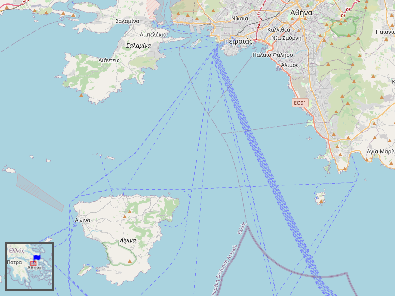
The map shows part of the Saronic Gulf in Greece with Athens in the north and the island of Aegina. The blue markers show the locations of the photos taken, which can be clicked on. The red markers open detailed maps. Use the back arrow at the top or double-click (tab) to return to the overview map.
Arrival
We took the metro to the port in Piraeus and then a ferry to the island of Aegina. We had booked a car with a local rental company a few days before so that we could get around the island.

Aegina Main Town
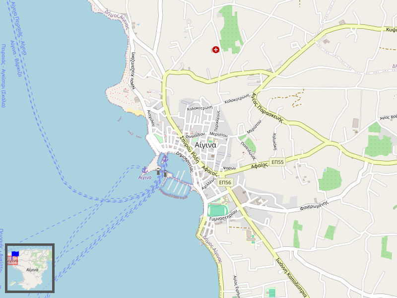
In the northwest is the main town of the island, also called Aegina. It has a harbor surrounded by small streets with shops and restaurants. There is also a large parking lot at the port from which you can explore the town.
Around the harbor
There is a ferry port and a marina. Throughout the year, ferries are operated by various companies between Athens (Piraeus) and Aegina. There are also connections to Angistri (island), Methana (peninsula) and Poros (island). The marina is very busy, especially on weekends.

Tower of Markellos
North of the harbor, on a small square, is the Markellos Tower, which is probably the city's best-known landmark. It is believed that the tower was built between 1687 and 1714. The tower was part of the defense against the Turks.

Temple of Apollo
The Temple of Apollo is located around 500 meters northwest of the harbor on the hill of Kolona. It consists of a large ruin and a small museum where artifacts are exhibited.

North of Aegina
To the north are fertile plains where pistachios, cereals, cotton, wine, almonds, olives and figs are grown. About 4 km from the north coast, the old Byzantine capital of the island, Paliachora, is located on a hill in the interior of the island. This place is also called Mystras of Aegina.

Temple of Aphaia
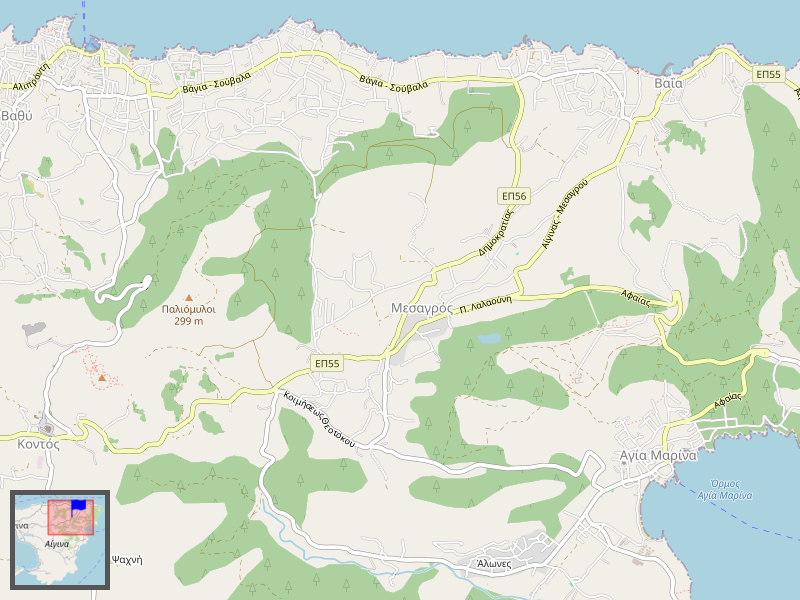
Near the village of Agia Marina, on a hilltop about 13 km east of the main town and port of Aegina, is the Temple of Aphaia, dedicated to the local goddess Aphaia. The temple was built around 500 BC.

Marathon Beach
We had an apartment on Marathon beach, about 5km south of Aegina's main town. There were beautiful sandy beaches and nice restaurants here.


Hiking on Aegina
Near our apartment on the beach of Marathon was a large uninhabited nature reserve with an old olive grove (Elaionas) on the slope of the highest mountain of Aegina, Hellanion Oros. I visited the olive grove twice and climbed the mountain once. The paths are very stony and require good footwear. I also recommend GPS navigation, as it can sometimes be difficult to find the exact route, especially in the mountains. (Especially if you take a lot of photos...). If you go further inland, you should take enough water and food with you, a hat and sun cream are recommended as there is hardly any shade. I was mostly alone on my hikes in October. Once or twice I saw another hiker. I underestimated the October sun, I recommend starting early in the morning even in October.
Ancient Elaionas (olive grove)
The so-called Ancient Olive Grove is located in the valley of Eleonas, a plateau about 2.5 km from the beach of Marathon, at an altitude of about 100 meters. It is estimated that some of the trees are over 400 years old. The trunks have a diameter of 2-3 meters. The olive grove is accessible via several paths.

Route via Pachia Rachi
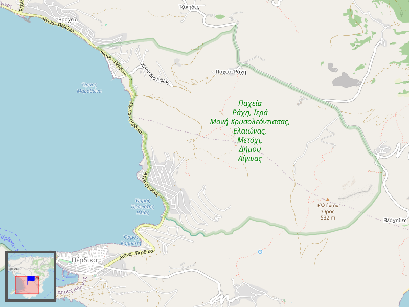
The first path I took from Marathon beach led through the village towards the settlement of Kapotides to the mountain village of Pachia Rachi with the church of St. Dionysius. A narrow path leads from Pachia Rachi to the plateau. The way back leads directly through the valley to the beach of Marathon.
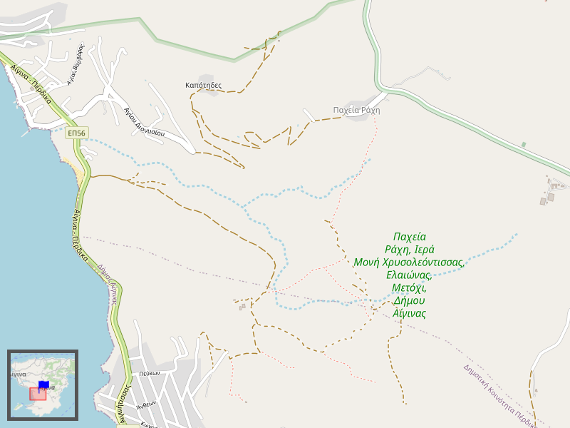
The path to the mountain village of Pachia Rachi at an altitude of around 200 meters was initially a paved road which then became more and more of a rocky mountain path.

A stony footpath leads from the mountain village of Pachia Rachi down to the olive grove.
The way back is relatively direct to the beach and you have a beautiful view of the bay.

Route via Aiginitissa / Perdika
On the second hike to the olive grove, I took the direct route and came back via Aiginitissa, a settlement belonging to the municipality of Perdika. The maximum altitude here is around 135 meters. However, at the end I had to walk along the little-used main road.


Mount Hellanion Oros
The hike to Mount Hellanion or Oros (Greek Όρος 'mountain'), the highest mountain on the Greek island of Aegina (532 m), is around 15 km long from Marathon beach. The path offers a fantastic view of Aegina and the neighboring islands.

Hike from Marothonas beach
Since, according to my research, there is no direct route between the Elaionas Valley and Hellanion Oros, I hiked via the mountain village of Pachia Rachi on the way there and back. The disadvantage of this route is the relatively long stretch of road between Pachia Rachi and the settlements of Anitseo and Portes. On the way to the mountain, I walked the path from Marothonas Beach towards Elaionas Valley and then to Pachia Rachi. On the way back, I took the direct route from Pachia Rachi to Marothonas Beach. After a long stretch along the road, you can walk a circular route on Hellanion Oros mountain. I first walked the narrow path via the Temple of Zeus Hellanios to the summit and then took the longer road back. There is a path on the summit itself, which I walked there and back.
From Marothonas Beach to Pachia Rachi
The first part of the trail leads from "Mathonas Beach B", from the main road at the end of the village, opposite a parking lot on the beach, up an increasingly narrow dirt road to the valley of Eleonas. In the valley of Eleonas, you can leave the olive grove on the right and walk to Pachia Rachi. This is already 200 meters in altitude.

From Pachia Rachi to the Temple of Zeus Hellanios
The stony path ends in Pachia Rachi and you reach the village road. The church of St. Dionysios can be seen on the left, but the path leads to the right in an easterly direction to a small country road. As there is no alternative hiking trail, you have to follow this road for approx. 1.7 km. This road with little traffic is then also part of the way back.

About 400 m after the crossroads, where another road branches off to Lazarides, there is a path with a parking lot on the right-hand side of the road, by a rock. This path leads to Mount Hellanion Oros.

Temple of Zeus Hellanios.
After about 300 meters, a small path branches off to the left to the temple of Zeus Hellanios. Not much can be seen of the remains of the temple itself, as it is overgrown with bushes. But a beautiful chapel, the Byzantine Church of Taxiarches in Aigina, is a nice substitute.

From the Temple of Zeus Hellanios to Mount Hellanion Oros
Behind the temple, in the direction of the mountain, a path that was difficult to recognize in October 2022 winds steeply up the mountain. The path goes along the west side. After about 2 km there is a turnoff to the summit.


Hellanion Oros Peak
It may not be the roof of the world, but the view from the highest point of the Saronic Gulf is fantastic. The chapel of the Prophet Elias on the summit was closed, but offered shade for a short rest.


The way down the Hellanion Oros
From the summit, take the same route back to the crossroads. Here you turn left towards the south. Follow this path until you reach a wider dirt track. Turn right here. This path leads back to the parking lot. At the parking lot, take the road back to Pachia Rachi.

From Pachia Rachi to Marothonas Beach
In Pachia Rachi, do not take the small road to the Elaionas Valley, but follow the village road past the church of St. Dionysios. The road turns into a dirt road and leads down the hill to Marathon Beach.


comments
from: on
Write a comment: